
SUPPORT
maps
I see trail running as a similar sport to "gravel" in cycling: it covers a wide range between smooth running (road, in cycling) and orienteering (mountain biking, in cycling). The idea is to get off the asphalt, but not to go floundering through trackless forest the way you do in orienteering. Sometimes it is pleasant, or sensible for your fitness goals, to run on a gravel-surfaced fitness trail, sometimes on easy trails and sometimes in genuinely technical terrain — but still, as a rule, using an existing path (short cuts through the forest, sometimes necessary, excepted). Like gravel, trail running has a sense of adventure to it: you go looking for new experiences in new terrain and on new routes, rather than sawing back and forth along the same familiar route clocking your kilometre splits and heart rates.
Trail running needs trails, of course (fitness trails, forest roads and so on included), and the great Finnish trail mapping project based on the OpenStreetMap community map (OSM) suits that need more than well. OSM trail mapping was originally born from the needs of mountain bikers, but the result suits trail running excellently too.
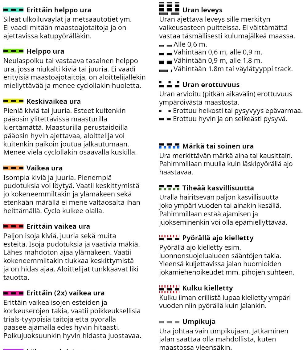
The trails on the Trailmap app's OpenStreetMap-based MTB maps (MTB, 3D MTB and MTB Winter) are classified with colour codes and other markings based on their "mountain bikeability". Although the classification is based on mountain biking, it can be applied to trail running well too, even if the correspondence is not quite 100%. This piece describes the classification from a trail running point of view. The writer is a long-time enthusiast of both sports, and further back in history there is orienteering in the mix as well.
The differences between the mountain biker's and the trail runner's problems in moving along a trail can be described, simplifying, as follows:
- For someone who has done at least a bit of mountain biking (and especially with a full-suspension or fat bike), the bike moves smoothly over even fairly big rocks and roots (up to about 20 - 30 cm) as long as it is possible to keep the bike's speed up, or alternatively some of the obstacles can be ridden around. The bike's speed keeps up well downhill, or if on the flat the obstacles come occasionally or in small clusters. Riding gets hard fast if you cannot maintain speed: the obstacles come too thick and fast, or they are on climbs, or they are preceded by bends / twists in the trail or other things that force you to slow down. Another thing that is often hard for the mountain biker is "micro-level" elevation change on the trail, i.e. frequently repeating holes over 20 cm deep, especially combined with rocks & roots and a twisting trail.
- For the runner, rocks, roots and unevenness on the trail slow you down and make running heavier going relatively linearly. On a bike, especially at faster speeds, the effect is different: sparse roots & rocks are ridden over at speed and barely slow you down at all. The effect of a descent is considerable: a skilled rider moves remarkably fast and effortlessly down even a rough trail compared to a runner. Then once the obstacles start coming thicker, cycling relatively quickly becomes first slow and heavy going (speed at the runner's level, but the effort possibly already heavier), until, as the trail gets harder still, the rider is forced to get off and push.
- Even short steep climbs or bigger "drops" (which the most skilled riders can still take, but the majority cannot) require getting off, which both slows you down considerably and, if it recurs often, ruins the "flow" of moving. For a runner, obstacles like that often mean just a few walking steps and do not ruin either the speed or the mood.
- On green and easier yellow trails I move by bike at almost 2x the speed at the same effort compared to trail running, but the difference shrinks very quickly as the trail gets more technical, and on a harder-end yellow / early orange trail the speed (at the same effort level) is already very much on a par with trail running. On a hard orange or red trail I am already clearly faster running than on the bike.
The colour classification of trails through a runner's eyes
Blue-green (very easy path): For running, in practice the same as a flat, well-maintained recreational path / fitness trail.
Green (easy path): for running, very even and fast trail, where you may occasionally have to lift your foot a bit more than on a fitness trail so you do not trip. Most often either the pine-needle trail of an esker, smooth clay-based trail, or trail evened out with gravel.
Yellow (moderate path): This is "proper" trail running already, where you do have to lift your foot over roots or rocks. At its easiest the trail may be only slightly harder than an easy path and the running goes straightforwardly at an even, self-chosen stride rhythm. But at the other extreme there start to be enough rocks, roots or unevenness that you have to vary your stride rhythm as you run and fit your steps into suitable spots on the trail. For someone fit who has done some trail running, these trails are still fast to run, and you can do easier steady-state runs on them too, allowing for the elevation on the route of course.
Orange (hard path): For a mountain biker a trail like this starts to present a proper challenge, especially in the wet. For a trail runner, though, the increased rocks, roots and other problems on the trail mainly mean more lifting of the feet and a greater need to fit your stride rhythm to the trail's features. On orange trails there start to be differences in how technicality is interpreted between mountain biking and trail running: what is technical for the mountain biker — the trail twisting combined with uneven ground and, say, small 30 cm rock steps — may slow the trail runner considerably less. So a trail like this is usually still smooth running for someone who has done some trail running, but for a beginner it may mean occasional walking sections of a few steps.
Red (very hard path): You find mountain bikers on these trails remarkably rarely, the exception being some descents where a skilled rider still moves smoothly even on a bike. For the trail runner these are still perfectly usable paths, but be prepared for even an experienced runner's speed to drop and to turn in places into brisk walking. To my mind these suit trail running mainly as short stretches on a longer run; I would not run a whole run on trails like this except as a specific technique session.
Wet / boggy (blue dots beside the trail): The markings indicate that the trail is wet either year-round or seasonally (spring when the snow melts, and the autumn rains). The scale is quite wide: it may be a trail with notably plentiful muddy spots when wet, or a stretch of bog that you have no way of getting across with dry feet. When you head for a trail like this you should at least be mentally prepared for wet feet, and in the wet season the recommendation is waterproof running socks.
Dense vegetation (green dots beside the trail): The markings indicate that the trail has abundant vegetation either seasonally (midsummer and early autumn) or year-round (e.g. a harvester path that has grown over with brush). There is so much vegetation that it usually makes moving along the trail at the very least slower, or unpleasant if the dominant plant is nettles. If you have planned a trail like this into your route, it is worth checking, just in case, whether there is a suitable way around it in case the vegetation turns out to be unpleasantly abundant on the day. At a pinch you can always get through these, and the trail is there to move along.
Red cross lines on the trail: Markings on one side of the trail indicate that cycling is entirely prohibited on the trail (a nature reserve restriction, say), and red markings on both sides of the trail that all access is prohibited, usually because the trail runs through a yard. And if a trail ends up in the yard of some buildings, it is worth thinking about whether you can go around the yard, e.g. by stepping off the trail into the forest.
The descriptions above will hopefully help trail runners make use of MTB maps for planning their runs, but they are needed even more when a trail runner adds or edits trails in the OpenStreetMap database and considers what classification (the mtb:scale tag used by the MTB map) to give.