
SUPPORT
trailmap
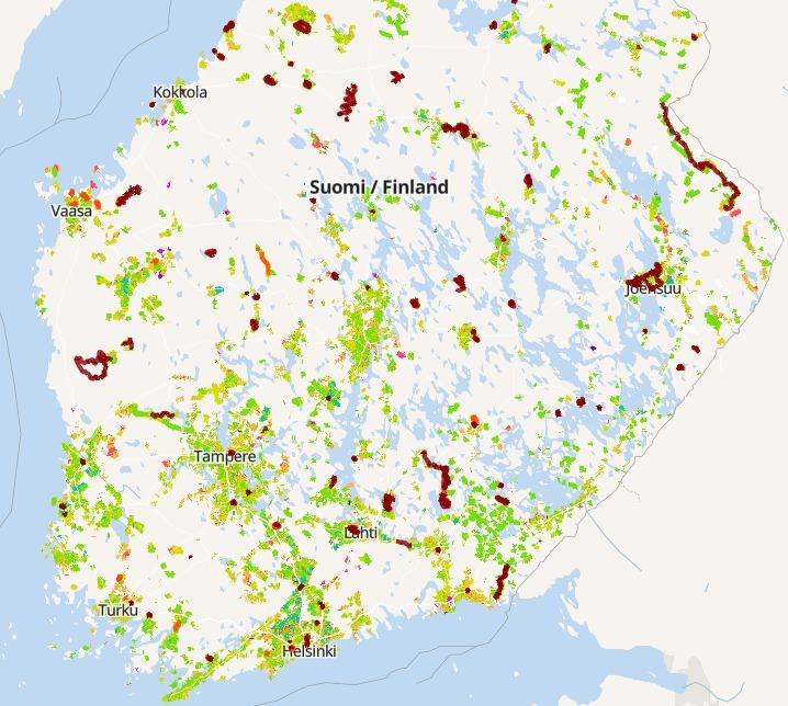
Now where was that trail suitable for mountain biking again? Oh, there is plenty — in spring 2024 over 24000 km of it all around Finland! Take a look at https://web.trailmap.fi/maps/overview and you get an overview of the classified mtb trails, waymarked mtb routes, bike parks and other cycling spots. In Trailmap's familiar way, the colours from green through yellow to deepening red tell you the difficulty level (like traffic lights); the thinner ones are singletrack, the thicker ones dual track. The darker red colour is official waymarked routes.
 The Trailmap mtb map
For the mapping and classification of the MTB trails we have the diligent OpenStreetMap (OSM) trail mappers to thank. The mapping started in 2013 and has advanced in decent steps over the years, accelerating significantly in 2020. The last few years have brought some 3000 km of new classified trails per year.
These trails are of course good for more than mountain biking — gravel riding, trail running and hiking, for instance. In those sports too it is useful to know what kind of trail is on offer out there, so you can pick the one that best suits the need at hand.
In OSM trail mapping, by the way, we are almost the champions of Europe. Only Italy is a bit ahead (for now…). This bit of information is worth passing on to those riding mates who still imagine that riding trails (or trails in general) are to be found on the National Land Survey's NLS topographic map. You can also give this post a thumbs up so the word spreads better. Look at a proper trail map and there is plenty to ride.
 Trailmap on the left, MML's NLS topographic map on the right
Note. The trails on the OSM map are not official routes — you move on them under everyman's right, and then you always have to use your own judgement so you do not stray into yards, saplings or anywhere else you are not allowed to go. These have of course been marked on the map where possible, but no map is 100% accurate.
 An example of a "no access" road into a yard, with red edge markings
The official routes and cycling spots come from JYU's LIPAS database, which is the official national database of sports facilities — although as it stands it does not cover all the official routes waymarked out in the terrain.