
SUPPORT
trailmap
Nearly 500 users answered the summer 2024 user survey, and their answers brought valuable information and feedback. The app's development seems to have gone in a good direction, and the completely rebuilt version (Trailmap v2) has had a positive reception. The feedback is a good basis for carrying on with development.
The user survey asked about:
- Background: how often, which versions of the app and for which sports you use it
- The importance of features: how you use the app (features), what matters most, where Trailmap is at its best and how useful it is for your sport
- Development priorities: difficulties in learning to use it, things to improve and which new features are most wanted
From these questions came a fuller picture than before of the user base, of how people use the app and of its functionality. On the basis of the feedback, development of the app can be aimed at the things that matter most to the user base.
The user base
Trailmap started from mountain biking and riders still form the core of the user base (74% of respondents). But enthusiasts of other sports have come along with the new version of Trailmap: gravel riders in particular, but also walkers and trail runners. Clearly the largest user group is "active outdoors people", i.e. people who do several sports — typically mountain biking as one of them, often gravel riding alongside it, plus other activities such as walking.
A bit over 60% of respondents had already used the earlier version of Trailmap. New users have arrived steadily through various channels: got a recommendation from friends, heard about it on social media, and a clearly smaller share found it by googling or from an app store list.
With the new version of Trailmap, the map and route planning features have been extended to other sports, especially gravel riding. It is great to see that this has also led to the user base widening, although this development will certainly take its time — there are many different apps out there for gravel, and it takes a slightly deeper-than-surface understanding of maps and routing for a user to appreciate Trailmap's strengths.
People who move on foot only (trail running, walking, hiking) are still a relatively small share of respondents (about 10%) given how many people do those sports. At least the following factors probably play a part: the traditional, familiar NLS topographic map has a very strong position (as users do not really know of anything else), people are used to moving mostly on waymarked hiking routes, and — surprisingly — even trail runners move on trails that are new to them remarkably rarely. That last observation was quite a surprise to me, because through my own trail running I had equated the sport with mountain biking (in terms of how widely people go adventuring on new trails).
Patterns of use
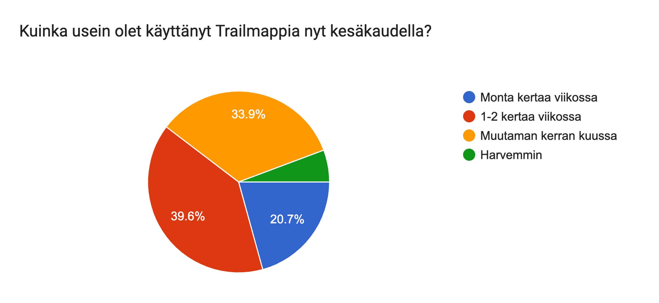
22% of users use Trailmap at least 3 times a week, over 60% at least once a week. 95% use it at least a few times a month. There are two equally strong groups among users: 1) those who use both the web and the mobile app and 2) those who use only the mobile app. A slightly smaller share than those groups use only the web app (and presumably a Garmin or similar device for navigation). About 7% of users also use Trailmap's map in some other app.
On a scale of 1-5, Trailmap's importance ("usefulness") for people's sport got a very high score: the average was 4.7.
In interpreting the answers in this section, the biggest thing to bear in mind is that a user survey is still only a sample of users. Respondents presumably include a larger share of very active users than the user base as a whole. So other metrics are needed as well when interpreting the overall picture.
The most important features
The most important features — and at the same time Trailmap's strengths — turned out to be the app's one-of-a-kind trail map (coverage & classification) and the advanced route planning features. Behind those came the breadth of the map selection and the mobile app's navigation features.
The strength of the trail map was no great surprise — there has been plenty of feedback about it already, and comparison against other apps on the market has confirmed the sense of how unique it is. The lead has grown further with the new vector map, as it has been possible to combine the best parts of the different map data sources (OSM, MML, LIPAS).
It was great to see route planning rise this high in users' actual use and appreciation, and its importance and volume of use in particular were at a clearly higher level than previously assumed.
Usability and learning
Feedback on developing the app was spread wide, as expected: users' sports, ways of making routes, the devices they have, experience of similar apps and so on all affected whether they wanted new features or wanted the existing features to be easier to use.
Generally the hardest things to learn were (in order):
- The difference between the web and mobile apps
- Map symbols
- Map settings
- Route planning
The topics on the list above were pre-selected for the survey, so answers concentrating on them was no surprise. The order I could not have predicted, though — I would have expected roughly that list in reverse. This is worth discussing further, e.g. on the "Trailmap Suomi" Facebook forum, to find the best ideas for how to tackle these problems.
The last two on the list can be addressed with extra guidance, of which YouTube & webinars will probably work best. From the written feedback another significant group emerged: answers asking for features the app already has — which tells you that for one reason or another users have not found these features in the interface. Most of these features are already described in the help pages, so something new needs to be found to make them easier to discover.
Generally speaking usability was felt to be good: the app's balance between a straightforward map-based interface and fairly rich functionality was seen as successful. Several people noted that "the features are easy to learn by trying them", and that is what the interface is designed for: nothing "dangerous" happens without a confirmation prompt, so it is safe to press the buttons in the interface experimentally to see their effect on the map or the route.
The written answers brought plenty of usable feedback on the details of usability: power consumption while navigating, centring the map, the direction arrow on positioning, route drawing technique, the popups at the start of the web version and so on. Some of these details show up on particular devices and in particular situations, some more widely. The feedback gave a better overall picture of the situation and this helps with polishing the details of usability.
New features
The wishes for new features were spread astonishingly wide, but the long list also contained a set of things with broader support:
- Route planning in the mobile app too — with this one it is hard to say how big the actual significance for use is, or whether it is largely about learning the differences between the web and mobile apps
- Routes published or shared by users made more widely available
- Custom points (POIs) on the map: for planning and for marking on the ride
- Converting a GPX (track) into an editable route of your own
- A touring bike routing profile: somewhere between Gravel and "safe cycling"
What the wishes had in common was that most of them centred on routes and route planning, as the list above shows.
Thanks to the discussion in the "Trailmap Suomi" Facebook group among other places, not a single item on the list above was completely new. The user survey did, however, give more information about how many people wanted a given new feature.
One piece of feedback that came from several respondents was the observation that caution is a virtue when adding new features: they almost always add at least a little complexity to the app's interface, so new features should benefit a significant share of the user base. As the developer I can say that the same phenomenon is even stronger on the development side: every new feature adds to the maintenance workload and hurts the productivity of new development by a surprising amount.
The discussion about new features will continue in the "Trailmap Suomi" group so that I can gather needs and ideas in more detail.
Summary
Trailmap has come a long way from the 2018 "Bikemap" app to the past year's hard grind on the development of Trailmap version 2.
Going by user feedback, the considerable work done has fortunately not gone to waste, and Trailmap has managed to bring the market a clearly distinct option, especially for people who move on trails and smaller roads (forest roads, recreational paths). The retention of long-standing users and the steady growth in user numbers say the same. And those who use the app at all use it pretty often.
The decision to focus on a one-of-a-kind trail map, on a wider map selection supporting it, and on capable route planning looks like the right one. The user survey strengthened my belief that it is better to aim at being the best on the market at a few chosen things than to make an "everything for everyone everywhere" app, of which there are plenty already. That focus naturally also limits the size of the user base, but in return those users can be offered a solution that stands out strongly and positively from other apps.
So the journey has gone in a good direction, but there is an excellent amount of potential left to develop the app's usability, help pages and features — and the user feedback gave plenty of valuable ideas for that. On that note it is time for the developer to get back to the lathe and grind out some code and some help pages!